The North Kent Coast
This page presents the results of research on physical processes operating along the coast of Kent near Herne Bay, conducted over many years with former colleagues from Wilson's School, Wallington. These processes involve the interaction of weathering and river action, wind strength and direction, waves and tidal currents, and human activities, and have resulted in considerable coastal change. The causes and consequences of recent changes at key locations between Whitstable Bay in the west and Reculver in the east are the main focus of this article.
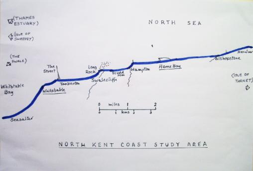
Location and general characteristics: The area of study lies approximately 55 miles east of London, and consists of a north-facing 5 mile stretch of Kent coast, two or three miles downstream from The Swale, that part of the mouth of the River Medway that separates the Isle of Sheppey from the mainland. Here the combined estuaries of the Rivers Thames and Medway open out into the North Sea, and the physical development of this coast is therefore affected by both estuarine and coastal processes. The Thames and its tributaries have deposited much alluvium into the southern North Sea over thousands of years, depositing it as spreads of silt, and banks of sand, shells and shingle, some of which support Herne Bay Pierhead, the Estuary Forts, and Kentish Flats Wind Farm visible out to sea. The rivers also scour out shifting channels in the sea floor, particularly on the fast-ebbing tide, and the estuaries provide a corridor for the prevailing wind and weather from the west. The North Sea, on the other hand, is a relatively shallow basin with strong anti-clockwise tidal movements, partially enclosed in the south, but particularly susceptible to winds and storm surges from the north and north-east. The wide, shallow offshore zone exposes extensive mudflats and shingle bars at low tide, particularly in the bays. At high tide steep shingle beaches (mainly of flint resting on sand) protect a very low-lying alluvial plain to the west reclaimed from tidal salt marshes (Seasalter Level), and a succession of small bays and river mouths further east (eg Swalecliffe Brook, West Brook at Hampton, and Oldhaven at Bishopstone Glen). Whitstable, Tankerton and Hampton Bays are not symmetrical: they are skewed so that their sharpest cusps are at the eastern end, where their streams enter. They therefore face the prevailing wind from the west, but are partly sheltered from dominant winds and waves transporting shingle from the east. They also experience anticlockwise local movements of tidal water within them, which increases the scour effect, and occasional strong rip currents just offshore which speed up longshore transport. The shingle beaches are almost continuous along our coast: they used to front and protect clay cliffs rising to over 20 metres at Tankerton, Studd Hill and East Cliff (Herne Bay), as they still do between Bishopstone and Reculver.
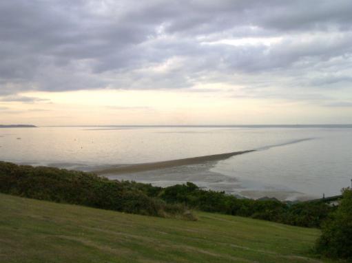
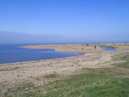
1. Aerial view westwards from Hampton to Tankerton, via Studd Hill and Swalecliffe (cf 4a below). Note the asymmetrical shape of the two bays shown, also the shingle building up against the pier in the foreground, and the lack of beach material on the opposite ( bay) side.
The coastline is constantly changing: beaches may change shape and gradient overnight, shingle moves along the coast according to seasonal variations in wind and waves, tides and currents; the cliffs have retreated repeatedly under attack by waves, surface water, and atmospheric weathering; the low-lying areas have been frequently subject to flooding from rivers, runoff, storm surges, and high tides. All of this has had a considerable impact on the local environment. In common with the whole of south-east England, north Kent has been sinking since the end of the Ice Age, and this, along with possible sea level rise as a result of global warming, will make our study area even more vulnerable to change in the future. Geologically, the coast is mainly founded on Mesozoic Upper and Middle Chalk, interleaved with prominent bands of flint, and overlain with varying thicknesses of Lower Tertiary London Clay which makes up most of the visible land surface and cliffs. Older sand and gravel beds beneath the Clay are exposed at Reculver and Bishopstone, and recent alluvium occurs around river mouths. Some shelly sands in the cliffs are remnants of raised beaches dating from changes in sea level towards the end of the Ice Age, eg at Reculver. All these parent materials are soft and vulnerable to erosion. Most of the sand and shingle making up the beach is derived from local parent rocks, but the presence of stones and minerals from well beyond Kent suggests that some of the beach material may have been derived from the ice sheets that formally occupied most of the North Sea Basin. Inland the North Kent coastal plain gives rise within a mile or two to the steeper backslope of the Kentish Downs; often wooded, its springs are the source of the small rivers draining to the North Sea across the coastal plain, and the site of the older villages and roads that link London with Kent’s ancient gateways to the Continent. Relatively isolated and sparsely populated until the early 19th century, the coastal economy used to be primarily agricultural with subsidiary fishing (Whitstable was well known for its oysters until very recently). Then the development of railways and shallow draught steam ships ('packets') led to Victorian and Edwardian seaside development at Whitstable and Herne Bay. Piers and jetties were built to offset the high tidal range and shallow foreshore, embankments and sea walls to act as a barrier to coastal flooding and cliff erosion, and wooden groynes to reduce the coastwise drift of shingle along the beaches. (Incidentally, the name Herne Bay appears at first sight to be a misnomer - it dates from railway era attempts to attract more trippers, when there was a small embayment between the East and West Cliffs; this was quickly filled in and built upon, but was still susceptible to flooding until recently). Twentieth century growth of car ownership and the growing popularity of watersports (particularly at Whitstable and Hampton) encouraged day trips and weekend excursions from east and south-east London, supplemented increasingly by retirement and second home development, as well as chalets and mobile homes on low-lying land at Swalecliffe. Successive coastal works have attempted to reduce the impact of physical change on housing and recreation, with varying success. The front at Herne Bay in particular has recently undergone substantial modification to reduce the danger of flooding, focused on the building of a protecting 'mole' to the east of what remains of the Pier (severely damaged in 1979). All of this growth and change has had a considerable effect on the environment, landscape, and physical processes operating along the coast, which we shall now consider with reference to specific examples.
[NB: Some photos below have been temporarily removed]
Hampton Bay and Studd Hill:
The lost village of Hampton began life as a small fishing hamlet at the mouth of West Brook, just west of Herne Bay. In the mid 19th century the Herne Bay and Hampton Oyster Company (hoping to cash in on the success of the nearby Whitstable oyster trade) replaced the small wooden jetty just to the east of the river mouth with a solid stone breakwater, along which a tramroad ran to connect the fishery with the railway line to London. They also built houses and a sea wall to protect them just across the river, and had grand plans for a new resort to rival Herne Bay itself. The pier was to be not only a means of unloading and transporting the oysters, but also protection for the oyster beds. However, the new breakwater interrupted the longshore transport of shingle from the east, and the natural replenishment of the protecting beach was much reduced. The oyster yield was below expectations, and the houses and their protecting walls were progressively washed away by a series of storms and floods, up to and including the Great North Sea Storm of February1953. The bay itself was enlarged, and the access road along the top of the cliff at neighbouring Studd Hill disappeared, threatening the survival of the houses backing onto it.
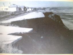
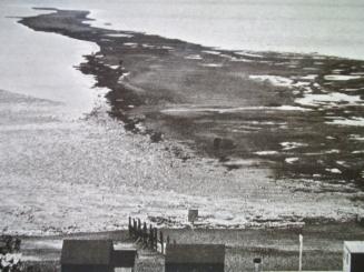
2a. Studd Hill clifftop after the North Sea Storm of 1953. 2b. Today's sea wall at Studd Hill after a spring tide.
Much of the beach shingle was removed and the old sea wall destroyed by the 1953 tidal surge, exposing the foot of the cliffs to highly destructive northerly winds and waves, and cutting them back some 20 ft. The replacemant wall was more substantial, and has protected the regraded cliffs and houses above, but note: the shingle beach is now overtopping the groynes and the wall ... (NB the same houses are shown in both photos)
As a result a new sea wall has been built to protect the whole coast from wave attack; the beach has been replenished and the groynes replaced; the channel of West Brook has been stabilised, with sluice gates to control discharge and reduce tidal variations; and drainage and slope reduction measures have been put in place along the cliffs of Studd Hill. A substantial rock armour barrier ('rip-rap') has been added to protect the western side of Hampton Pier. However, there is evidence that the coast protection measures in Herne Bay, along with the strengthening of Hampton Pier, may incidentally be causing further problems: shingle accumulation on the east side of the pier, and accelerated removal and transport on the bay side. Canterbury City Council and the Environment Agency have just announced that further beach replenishment and stabilisation work will be necessary at Hampton, and further west at Studd Hill and Swalecliffe...
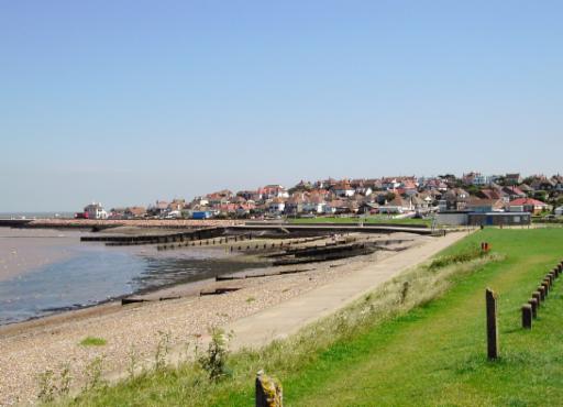
2c. Hampton Bay from Studd Hill: the former Oyster Company pier is on the left, with the 'Hampton Arms' (a survivor of the old village) overlooking the remains of the early sea defences; the modern sea wall is some two hundred yards inland of its 19th century position. West Brook enters the bay from the right. Notice the shingle beach overtopping the groynes, the muddy foreshore below it, and the cliffs of Studd Hill rising towards us.
Whitstable 'Street':
This 1/2 mile long shingle ridge jutting out into the sea below Tankerton Slopes has been a prominent feature at low tide for hundreds of years, whose origin has been the subject of much speculation. It seems highly unlikely, as has been suggested, that it was constructed as a Roman Road (a road to nowhere?), or an old jetty (unnecessarily long, and why shingle?), or even protection for the Whitstable oyster fisheries (ditto, although it may undoubtedly have been useful in that regard). The evidence points to it being a natural feature resulting from the interplay of waves and currents from opposing directions - river and tidal influences from the west and longshore drift of shingle from the east. Waves and currents from the west sweep shingle and sand anticlockwise around Whitstable Bay to the harbour, where it meets shingle driven west in Tankerton Bay. The resulting accumulation has built out to sea at right angles to the shore, until it meets Thames Estuary currents that cause it to turn slightly eastwards. Comparisons might be made with Dungeness on Kent's Channel coast, which developed as a result of similar opposing movements of shingle; however, in that case they produced a cuspate foreland, rather than The Street's narrow finger ...
3a. The Street, looking NW from Tankerton Slopes up the Thames Estuary. The Isle of Sheppey and The Swale are on the left; Foulness and the Essex marshes are on the horizon opposite. It is oriented slightly NNW from near the point where Tankerton Bay meets Whitstable Bay. The triangular apron at this end shows evidence of sedimentation from both east and west. Note the corrugations in the grassy foreground: the result of intermittent failure of the London Clay slopes when saturated by rain.
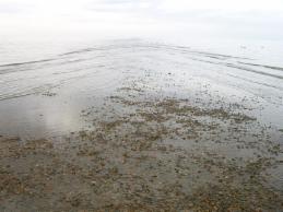
3b (left). Intersecting waves from west and east near the seaward end of The Street. The accompanying movements of shingle from both directions result in this narrow shingle ridge. It appears straight here, but further out it curves slightly to the east (right as we look), and in former times it was more sinuous in plan.
3c (right). Looking back towards Tankerton, there is a clear contrast between the steeper, newer shingle on the west side and that on the east, reflecting recent dominance of estuary currents and wave action over North Sea coastwise drift. Note the flat top, and the shape of the stones: smaller, more rounded and more uniform than on the beaches, suggesting long-continued low energy wave action in a shallow environment.
3d. The Street in late Victorian times. A photograph taken soon after the Whitstable oyster trade reached its peak, it is about the same length as today, but much more sinuous and irregular in form; there is nothing to suggest any kind of man-made influence at work. Note that it appeared to curve westwards at the end then.
Long Rock, Swalecliffe:
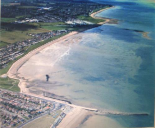
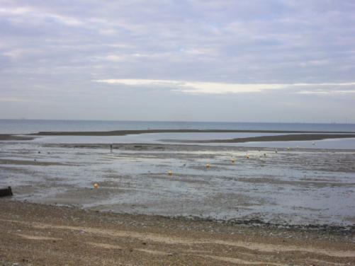
Here a 400 metre shingle spit has developed across the mouth of the Swalecliffe Brook, diverting it successively westward towards Tankerton Bay, leaving freshwater 'swales', alluvial marshes and shingle ridges behind it. Offshore, a complex series of shifting banks and shoals has become increasingly visible at low tide. Photograph 4a below was taken at about mid-tide, and the shingle banks are just being uncovered on the left. The delta-like fan dominating the foreground seems to be composed of a combination of accumulating coastal shingle, silt from the river and former effluent from a nearby sewer outfall. This was formerly a productive fishing area (old maps show many fish traps and 'weirs' off this point) but nowadays there are notices warning against both swimming and consuming shellfish here ...
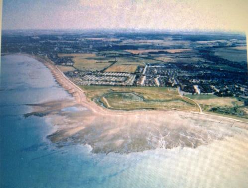 4a. Aerial view of Swalecliffe and Long Rock from the NW. Studd Hill and Hampton Bay are in the left background, Tankerton Bay is to the right. Swalecliffe Mobile Home Park in the centre is protected from N Sea high tides by a sea wall and shingle beach. Swalecliffe Brook meanders towards the sea from right to left, then is swept back towards us by the westward growth of Long Rock shingle spit.
 4b Long Rock shingle spit from the south-west. It has been formed as a result of longshore drift under the action of waves driven by dominant winds from the north-east (see 4c below). Waves from the N and NE have higher energy because they build up over a longer distance of open sea (have greater fetch) than those from other directions, so shingle is moved generally east to west along the beach. However, here at the start of Tankerton Bay the coast changes direction, and the growing spit cannot extend into the deeper water; the shingle accumulates and waves from the north and west cause it to recurve back towards the land. The Kentish Flats Wind Farm is just visible on the horizon.
4c. The Swalecliffe Brook near its mouth, at low water. The river channel curves towards us between extensive shingle banks, which have accumulated by longshore drift from the east and diverted the stream to its present mouth (just behind us). The open sea is to the left. Salt -tolerant plants are colonising the shingle and stabilising it, marsh vegetation occupies the low-lying 'swales' and pools. Note the dry stream bed as the water percolates into the shingle - at high tide the water table rises and the stream continues to the sea; with greater discharge in wet weather the stream is able to move the coarser shingle in the foreground.
The shingle banks offshore (which I prefer to call Swalecliffe Banks, to distinguish them from the coastal spit) seem to be developing fast, and resolving themselves into irregular ridges elongating from west to east. There are two main ridges, the outer one of which is joined tenuously to the beach just east of the Long Rock spit, the other roughly parallel to it but more detached (see photo 4d). Although built of shingle, they are wider and less well-defined than Whitstable Street, and they support extensive mussel beds, particularly nearer the beach. Further out the ridges curve round noticeably towards Studd Hill and Hampton Bay to the east, suggesting modification by estuarine and tidal currents, and storm waves driving inland from the north.
While there may be some comparisons with Whitstable Street (particularly as the latter looked in photo 3d above), it seems to me that the Swalecliffe Banks have more in common with offshore bars than spits, such as those along the North Norfolk Coast (eg Scolt Head Island). North Norfolk has similar rocks and relief to North Kent, and a similar coastal profile and orientation with respect to North Sea winds and waves. Offshore bars develop where strong destructive waves approaching a shallow shore at right angles comb material straight back down the beach and concentrate it in the offshore zone, which seems a likely scenario here. However, this is speculative at the moment, and clearly more research is needed ...
4d. The Swalecliffe shingle banks (a developing offshore bar? or a spit?) at low tide. These banks are not as continuous, straight, or regular in height as The Street to the west, and they curve round to the east much more, suggesting different origins. Note the steep shingle beach resting on sand in the foreground, with larger stones at the bottom, and the almost flat foreshore beyond, composed of a mixture of silt and fine sand resting on London Clay. This photo is from 200 yds east of the Long Rock spit shown in photos 4b and 4c.
Bishopstone Glen:
Near the former coastguard station midway between Herne Bay and Reculver are steep unstable cliffs of Oldhaven Sand overlain by London Clay, into which the little Oldhaven Brook has cut a steep wooded valley. The stream has been truncated over the years as the cliffs have retreated, so that now it rarely has sufficient discharge to overcome the active drift of beach material across its mouth. It therefore has to reach the sea by percolation through the banks of shingle ...
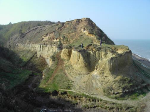
5a. Bishopstone Glen from the east. The little Oldhaven Brook is deeply incised into its valley on the left, exposing the unconsolidated sands of the Oldhaven Beds. Then it meets the permeable shingle beach visible on the right, which it has to percolate to reach the sea. Caissons are visible in the right foreground, an attempt to protect the vulnerable cliffs from wave attack: this was unsuccessful as storm waves undermined them!
5b. The Oldhaven Brook in Bishopstone Glen, looking upstream. We are less than 400 yds from the sea, but more than 50 feet above Mean Sea Level. As a result of cliff retreat the stream now cuts steeply down to reach the sea, firstly through London Clay, then through Oldhaven Sands. The steepening gradient caused the stream to cut down rapidly into its clay bed. This process of rejuvenation resulted in the 'knick point' seen here, with the former valley floor left as terraces on either side, some 20 feet above the stream (in the sunshine).
The cliffs and the valley side slopes are particularly unstable here, since the Oldhaven Beds at their base are very friable and vulnerable to undercutting by storm waves and running water, and also to weathering. The cliffs between Bishopstone and Reculver have no artificial protection, so the cliff retreat is particularly rapid - up to a metre a year. The instability is exacerbated by the presence of the London Clay on top, which becomes very heavy when wet, then slumps down or breaks away. Visitors to this attractive and interesting site have also played their part in initiating and accelerating erosion: paths have had to be rerouted, steps and bridges have collapsed and houses originally built some 200 or 300 yards from the sea are increasingly threatened ...
Summary and Conclusions:
- Our study area is located where the combined estuaries of the Thames and Medway rivers meet the North Sea, and is affected by processes associated with both environments.
- Its easy access from London has attracted many visitors, residents and commuters who put ever-increasing pressure on the coast.
- Its physical features are a result of the interplay of a variety of agents and processes, which have operated in the past in a state of dynamic equilibrium; but there have been many recent changes associated with human activity, eg coastal management measures to encourage recreation and to protect property.
- Overall the coastline is retreating under sustained attack from wind and waves: some parts, particularly the cliffs in the east, have retreated very rapidly in living memory.
- The coastline has been smoothed and straightened when viewed in plan: old maps show a more indented coast than now, with small headlands eroded away, as at Bishopstone, and shallow embayments filled in, as at Swalecliffe and Herne Bay.
- There are differences in the balance of the dominant processes operating between east and west: at Seasalter and Whitstable Bay estuarine deposition and tidal scour are more important, while further east wave erosion and longshore drift increasingly dominate. The two sets of influences are approximately in equilibrium on the stretch of coast between Tankerton and Studd Hill, which is where The Street and Long Rock have developed.
- The whole coast is characterised by a near-continuous shingle beach that formerly offered some degree of natural protection from all but the most severe storms, but this has now been backed by a concrete sea wall and supplemented by groynes to reduce longshore drift, which require expensive refurbishment or renewal.
- Beach material is generally transported from east to west by wave action; this has affected seaside and waterborne recreation, fishing, and navigation, as well as the way local streams enter the sea.
- As a result of the delicate balance between the input of beach material from the east, its coastwise transport, and its later accumulation or output in the west, changes affecting one part of the coast will have a 'knock-on' effect on other parts.
- Major storms, such as the Great North Sea Storm of 1953, have had a dramatic effect on North Kent, causing major changes to the environment as well as to people's perception and responses; storms may well become more frequent and severe in the future as a result of climate change induced by global warming.
- South-east England has been sinking since the end of the Ice Age, increasing susceptibility to floods; this too will increase if sea levels rise due to worldwide melting of glaciers.
It is clear from the above that, in an age of ever-increasing pressure on a sensitive coastal environment, and dwindling public finances to deal with its problems, some difficult decisions about priorities have to be made. It is vital that those decisions are well-informed: based on an understanding of the processes involved, and their likely impact on people and the environment in both the short and long term. It is to be hoped that this article will contribute in some way towards that end.
[ any comments or queries to me via email:
martindknight@gmail.com ]